


Sim89, described broadly in the previous section, is designed to process a so-called mass raid scenario, in which a few hundred primary threats are launched within a one- to two-minute time window, together with about 40 to 60 secondary, anti-satellite launches. The primary targets boost through two stages of powered flight (total boost time is about 300 seconds), with each booster ultimately deploying a single post boost vehicle (PBV). Over the next few hundred seconds, each PBV in turn deploys 10 re-entry vehicles (RVs). The Sim89 environment does not yet include the factor of 10 to 100 increase in object counts due to decoys, as would be expected in the ``real world.''
The data available for the tracking task consist, essentially, of line-of-sight
measurements from various sensing platforms to individual objects in
the target ensemble at (fairly) regular time intervals. At present, all
sensing platforms are assumed to travel in circular orbits about a
spherically symmetric earth (neither of these assumptions/simplifications is
essential). The current program simulates two classes of sensors: GEO
platforms, in geostationary, equatorial orbits, and MEO platforms in polar
orbits at altitude  . The scan time for GEO sensors is
typically taken to be
. The scan time for GEO sensors is
typically taken to be  , with
 for MEO platforms.
Figure 18.16 shows a small portion of the field of view of a MEO
sensor at a time about halfway through the RV deployment phase of a typical
Sim89 scenario. The circles are the data seen by the sensor at one scan and
the crosses are the data seen by the same sensor at a time
 later. Given such data, the primary tasks of the
tracking program are fairly simple to state:
later. Given such data, the primary tasks of the
tracking program are fairly simple to state:
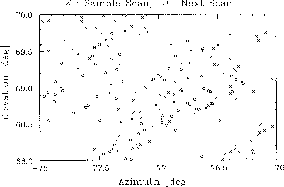
Figure 18.16: Typical Midcourse Data Sets, Consecutive Scans
In order to (in principle) process data from a wide variety of sensors, the Sim89 tracker adopts a simple unified sensing formalism. For each sensor, the standard reference plane is taken to be the plane passing through the center of the earth, normal to the vector from the center of the earth to the (instantaneous) satellite position. Note that these standard frames are not inertial. The two-dimensional data used by the tracking algorithm are the coordinates of the intersection of the reference plane and the line of sight from the sensor to the target. The intersection coordinates are defined in terms of a standard Cartesian basis in the reference frame, with one axis along the normal to the sensor's orbital plane, and the other parallel to the projection of the platform velocity onto the reference plane.